Chasing the Totality

Day Four: Nine Mile Canyon

From Boulder Town, UT 12 climbs sharply, roughly 3000 feet in 10 miles. Suddenly you are in deep pine forest, on top of the mesa with the red-and-white edges of distant mesas visible thousands of feet below.

Point Lookout

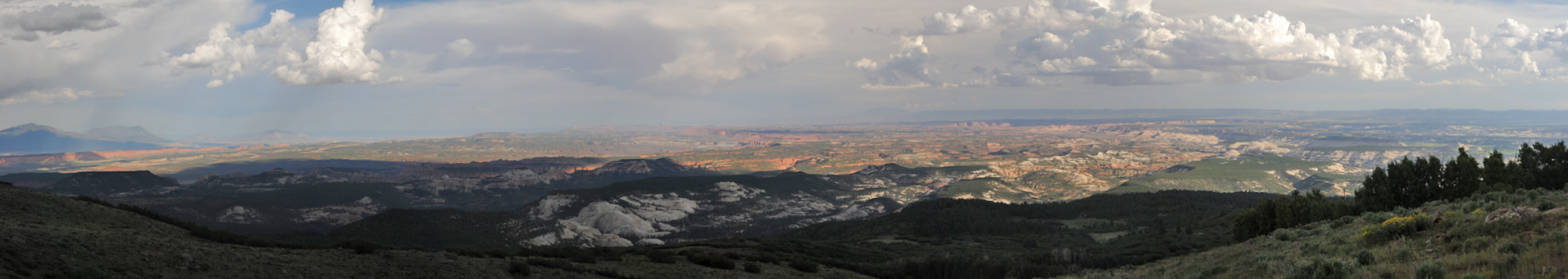
Panorama from Point Lookout.

On the other side of these highlands, UT 12 drops into into the Fremont River Valley, a bucolic landscape of lush green fields with red cliffs in the distance.
In Torrey, we left UT 12 for lightly-traveled UT 24, and then UT 72. The latter route climbs high into bare, round, green hills and then some pretty canyon country. We saw only one of two other cars on the road, no towns and almost no houses. We pulled off the road and put up the awning to enjoy a pleasant homemade lunch.
The route for this trip was planned around visiting Nine Mile Canyon. I'd been reading about this canyon for years. Often described as "the world's longest art gallery," the canyon contains tens of thousands of petroglyphs along a stretch of more than 40 miles.
The petroglyphs were created by the Fremont and Ute people, and in 1886 a road was constructed through the canyon to connect Fort Duchesne to the railroad line located in Price, Utah.
The canyon is on BLM land, so we planned to spend at least a full day here, hiking and exploring side canyons.
But although the canyon is public land, there is virtually no public access. Every single side road is posted, gated and locked, and it's hard to even find a place to pull off the road. There are a lot of petroglyphs in the canyon, but we had to take most of our photos from far away, and forget about hiking or camping in the area.
Nine Mile Canyon is caught in a tug-of-war between wealthy ranchers and the oil companies who covet its oil and gas reserves. In a trend that is widespread all over the Western US, ranchers who graze their cattle on public land have barred access to public roads, so that they can eventually declare those roads "abandoned."
In December, 2016, the BLM offered leases for oil and gas drilling on more than 1500 acres in Nine Mile Canyon, but the leases have been the subject of a protracted battle.

Access to the canyon was a huge disappointment, but we were delighted by clusters of Rocky Mountain Bee Plants, which were abuzz not only with bees but also hummingbirds.

And so we ended up cruising straight through Nine Mile Canyon and out the other side, where were found ourselves in a forest of oil rigs. This is the Green River Oil Shale Formation, rumored to contain "more oil reserves than Saudi Arabia". However the "oil" is actually organic matter known as "keragen" trapped in sedimentary rocks that must be heated to extremely high temperatures to convert it to petroleum.

We ended up camped on a side road, where nearby "Ant Hill" was the only bump on the landscape taller than the oil rigs.

Next: Rainbow Park, Dinosaur National Monument